
This fascinating article on Ixworth’s World War Two Defences was produced by The History Group of Ixworth.
To download or view the original article please click on the link to the “Ixworth’s World War Two Defence” pdf.
The Commanding Officer of the Home Guard in Ixworth was Major Gilbert Kilner; as well as being the manager of the Ixworth Cyder Factory he was an antiquarian and amateur archaeologist who left a treasure trove of notes and papers. One such item is a map of the defences for Ixworth.
Ixworth was designated as a Defended Place by the Eastern Command Defence Plan, the aim of which was to halt the advance of enemy armoured vehicles by defending major highway junctions. The whole village was surrounded by barbed wire with weapons pits and machine gun emplacements to give covering fire to the wire. The roads were blocked in several locations by either concrete cylinders or hairpins (angled sections of metal rail which could be set in the road). Where possible, roadblocks were given the option of flanking fire by Spigot Mortars which could fire anti-tank weapons from fixed concrete emplacements. There were already three pillboxes in the village and it was planned to fill significant gaps between buildings with minefields.
The contents of the map have been transposed on to a 1986 aerial image of the village which is posted here as Ixworth Defences. These notes accompany that image. There is little left to be seen of the defences today but some remain and there are supporting documentary sources.
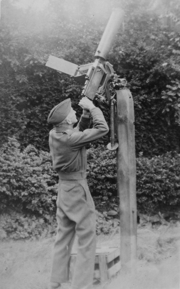
Major Kilner in his Garden
THE KEEP
As part of being a Defended Place a village was required to nominate a Keep. This was a defensible position to which the defending Home Guard troops could fall back during a battle and from which they would launch counter-attacks. The Cyder House (known in those days as Trayton House) was chosen, presumably, due to its size, defensible position, tactical location at a major junction and the fact that OC Home Guard lived there. Being part of the Cyder Factory it is said that Home Guard meetings there were very convivial.
Major Kilner erected a stout post in the garden of the Cyder House which he could use to mount a Browning machine gun for anti-aircraft use. He had been known to lean on his staff car and fire up at the passing Luftwaffe. He also cut small loopholes in the flint wall between the Cyder House and Dover House through which rifles could be fired across the minefield which would have run from the garden of Dover House back to the river.
The Cyder House sat at the centre of a complex of defences with major roadblocks around it, a pillbox beside it and an elaborate mortar emplacement.
PILLBOXES
Pillboxes were built in quantity in 1940 and tended to stand in relatively open locations close to rivers which were used as Stop Lines to slow the advance of invading forces. Ixworth was a Nodal Point in this early form of anti-invasion defence and stood on the Orwell to Great Ouse Stop Line. This ran from the mouth of the River Orwell via Ipswich, the River Gipping, Haughley, Tostock and the Little Ouse to Euston then via the Little Ouse to the Great Ouse.
There were two pillboxes on the outskirts of the village, both of which were blown up post-war (by a company called Blast-a-Stump) to allow for an expansion of agricultural acreage. One sat to the north of Wood Street (the extension of Crown Lane) and approximately 200m to the east of the bypass. The other was next to the Bardwell Road, probably 400m north of the bypass where a beet platform now stands. It is said there was another, disguised as a haystack, near the watermill.
There were also three pillboxes within the village itself. One stood in front of Bridge Farm next to the bridge (the bridge was rebuilt in 1951 after it was damaged by a vehicle). Another stood at the junction of the High Street and Stow Road. This one was built up against the side of the old fire engine shed and had a sloping roof so that it would blend in and be camouflaged from aerial reconnaissance. As a result its firing ports were very close to the ground.
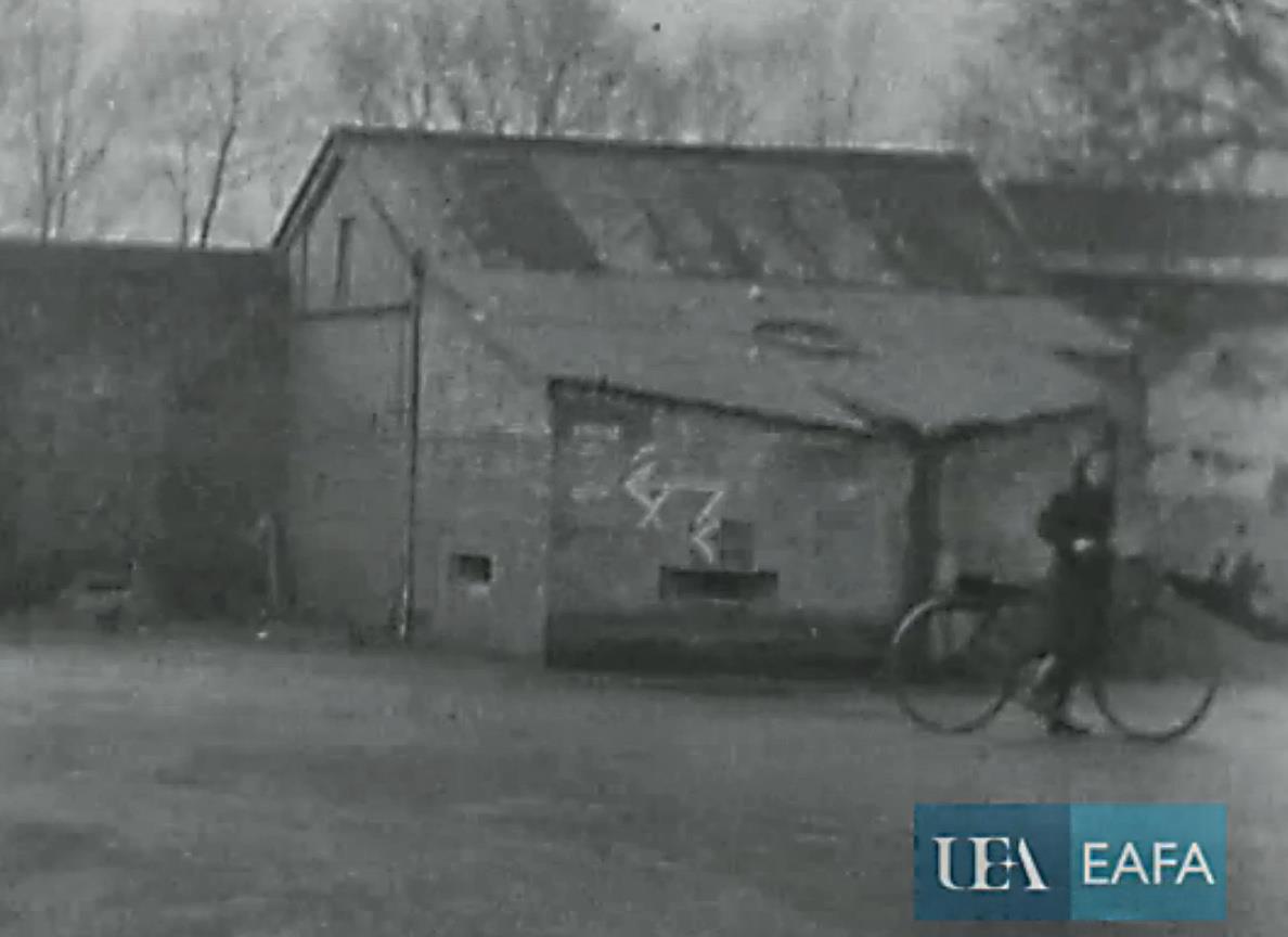
This image of the Stow Road pillbox is from a 1944 film about USAAF Honington on the East Anglian Film Archive website. It appears 5 minutes into the film.
The third pillbox was in the High Street and actually occupied nearly half of the roadway itself. Both the Home Guard sketch-map of the defences and the final version created by the Royal Engineers show this pillbox as being opposite The Beeches although some that can recall seeing it feel it was further up the High Street. In October 1943 a young girl was killed by a reversing bus at the Thetford Road junction; the Chairman of the Parish Council said that the incident could have been avoided if their suggested changes to the road layout had been adopted and, in November 1943, the MP for Bury St Edmunds wrote to the Secretary of State for War requesting that the pillbox be removed and quoting the accident as evidence of its danger. It was demolished sometime between April and October 1944 and cannot be seen in the EAFA film.
SPIGOT MORTAR EMPLACEMENTS
The Blacker Bombard or Spigot Mortar was a weapon which could launch either mortars or anti-tank weapons. It could be mounted on a flat ‘crucifix’ of legs for use in the field or on a concrete emplacement in fixed locations. A typical emplacement consisted of a concrete ‘thimble’ approximately three feet in both diameter and height with a stainless steel stud in the top. The thimble would be set in a circular trench with the stud at ground level. The mortar was secured on the stud so that it would be at the chest height of the men standing in the trench to operate it.
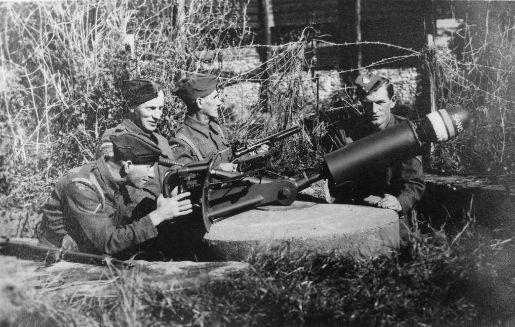
An Ixworth Spigot Mortar Emplacement – Possibly at Ixworth Abbey
Fixed spigot mortar emplacements were normally positioned to give flanking fire against armoured vehicles which had been halted by roadblocks. The defences map shows twelve spigot mortar emplacements in Ixworth but, to date, evidence of only five has been found. Some of the mortars seem to have been positioned to cover approaches across open ground.

Hill House, High Street, Remains of a Spigot Thimble
When houses were first built in The Paddock in 1969 a thimble was found which can be seen on the defences map covering Commister Lane from across a limb of the Abbey moat system.
The builders dug a pit next to it, toppled the thimble in and buried it.
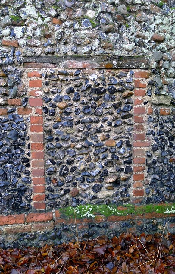
At the top of the High Street, at Hill House (formerly Street Farm) can be seen the remains of a thimble under a wall.
The strength of the concrete structure can be judged by the crude way in which it has been hacked down to level the surface for the bricks.

Street Farm Lane Spigot Thimble
In the garden of 23 Street Farm Lane there is a thimble which Wilcon Homes tried to remove when they developed the housing estate in a farmer’s field in 1981. They soon gave up trying to shift it. The position of this thimble is unusual. The defences map shows it in Thetford Road covering a roadblock near the junction with the High Street. In its actual position it is screened from both the High Street and Thetford Road by high flint walls, it sits outside the barbed wire of the outer perimeter and only gave cover to an open field. On the original plan for the defences this location was meant to contain a machine gun position and a weapons pit giving fire along the lines of the barbed wire. It may have been intended to attack tanks which were avoiding the village by going cross-country. Excavation shows that the walls of its trench were formed by a concrete slab along the base of the flint wall and a ring of concrete-filled sandbags.
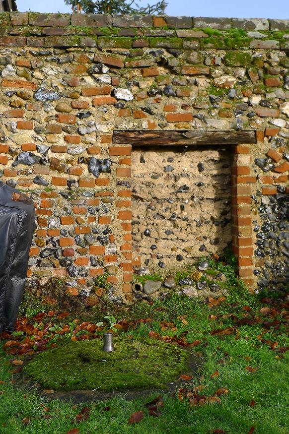
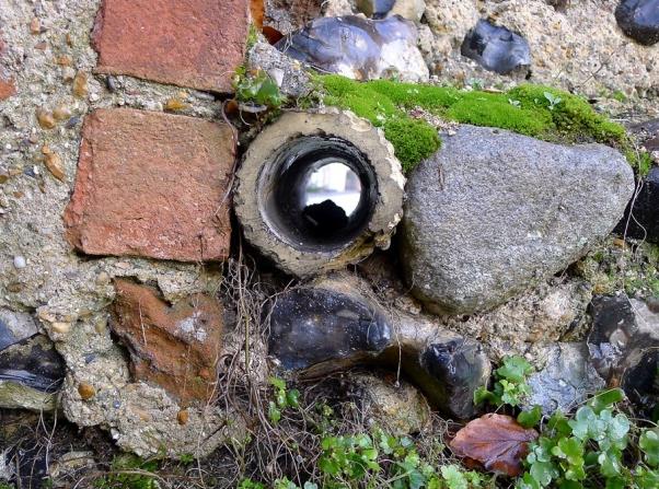
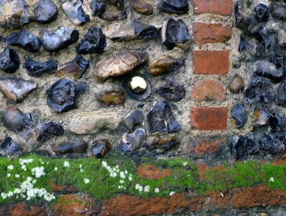
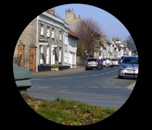
Of far more interest is an emplacement in the garden of Dover House. It sits very close indeed to a flint wall which borders the High Street/Stow Road junction. Beside it is what appears to be a blocked-up doorway in the wall, however, this ‘doorway’ is rather low, it is filled with only a single skin of flints and it has a wooden lintel. (This area of wall is immediately to the left of the pillbox in the image above.) Close to ground level there is a section of drainage pipe running through the wall.
When viewed from the Dover House side it makes more sense. When standing in the trench around the thimble, crew members would have been able to use the pipe as a spyhole and see the enemy approaching down the High Street. The ‘doorway’ could then be smashed out with a sledgehammer and the mortar fired through the resulting gap.
-
- The Dover House Spyhole and its View

We have described the spigot thimbles as standing in a circular trench but a normal Spigot Mortar emplacement would have had small, square ‘alcoves’ running off the trench in which ammunition was stored. Commonly the trench would have had a zigzag wall made of poured concrete with slabs forming the lids of the open-fronted ammo recesses.
The majority of emplacements across the country, as in Ixworth, have had their retaining walls demolished and their trenches filled, leaving only the resilient thimble itself. There is one in Ixworth, however, which is much more complete. Being located in woodland in the grounds of the Abbey there was no pressing need to demolish it. The thimble is standard on this example but its trench has brick walls with concrete slabs forming the lids of the ammo stores. Many older residents have happy memories of playing in this emplacement as children.
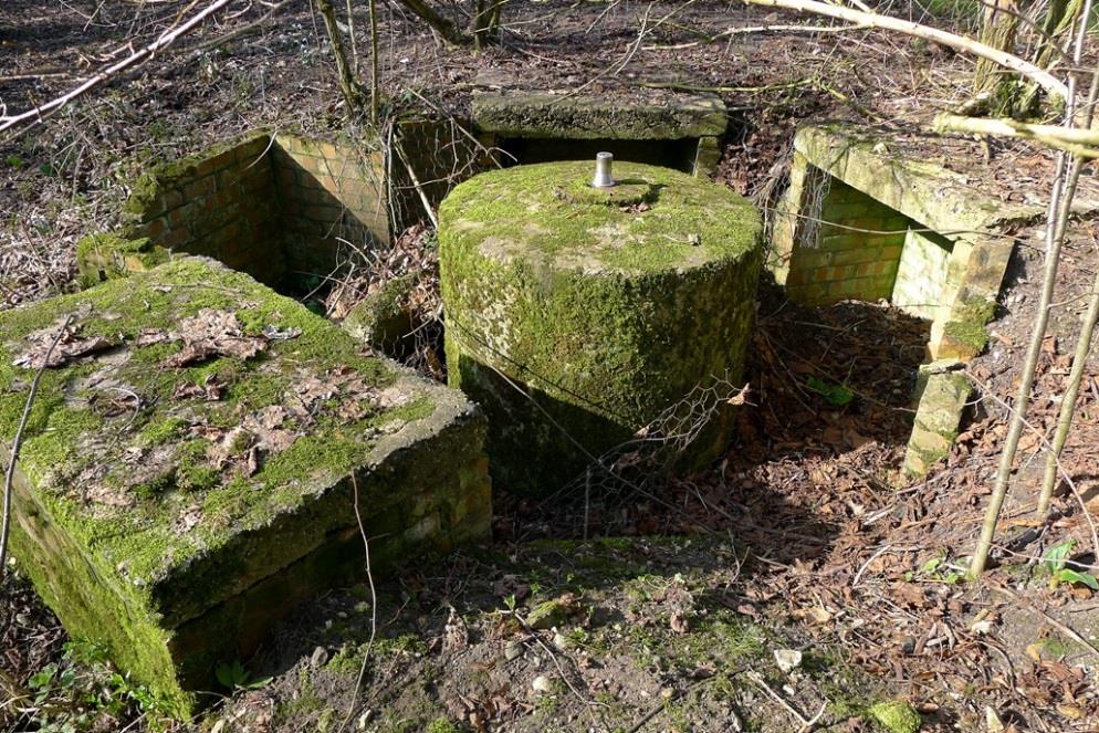
Ixworth Abbey Spigot Mortar
WEAPONS PITS & MACHINE GUN POSITIONS
Weapons pits and machine gun positions were placed in several locations, normally allowing fire to be directed along the line of the barbed wire encircling the village. They leave no sign because they were, effectively, simple trenches.
ROADBLOCKS
Roadblocks came in three types, concertinas, concrete cylinders and hairpins.

The defences map shows U-shaped concertina roadblocks at the outer reaches of the wiring plan in Thetford Road, Crown Lane and the Bury Road.
Concertina was simply the term for a stretched-out roll of barbed wire. They can be seen in operation here in an illustration from Home Guard Instruction No 51.
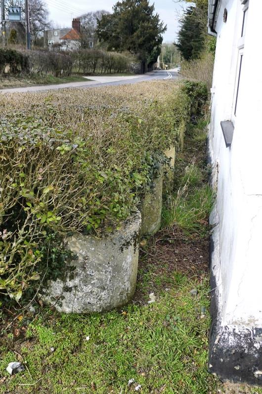
Recycled Cylinders in Tollgate Hedge
Concrete cylinders were mass-produced. They were 2ft in diameter and either 2ft 6ins or 3ft high. The ones produced locally have a steel loop set off-centre in the top of the cylinder and a hole through the centre. The standard arrangement was for the cylinders to be set out in ‘clumps’ of three – two of 2ft 6ins, one of 3ft. The loops were used to lift the cylinders and to tie them together. A crowbar in the central hole could lever them into position and tilt them for rolling. The cylinders were placed in outer locations like Thetford Road, Crown Lane and the upper High Street. They were also used to close small gaps between buildings and even to stop the Third Reich from taking a shortcut through the car park of the Greyhound.
Once the end of the war was in sight complaints about cylinders getting in the way were expressed. In April 1945 the Parish Council asked the County Surveyor to remove them. In response the County Council said they would pay the Parish Council two shillings for the removal of each cylinder and that, furthermore, they would not be charged for the concrete itself.
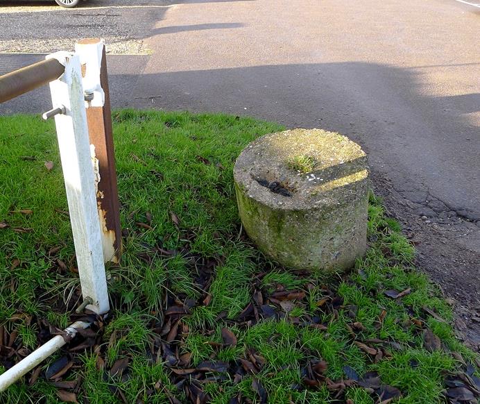
Cylinder at the Village Hall
This generous offer seems to have gone unheeded because in September 1945 the Parish Council Chairman reported that a cylinder had rolled into the roadway outside Hill House and caused a van to roll onto its side.
The Council repeated its request for their removal. Today cylinders can be seen dotted around the village: at Dover House Farm, the Village Hall, the Tollgate and Hempyard Bridge.
They were found useful when positioned to stop vehicles hitting the corners of buildings and could prevent erosion at the bridge. In the case of the Tollgate a long row of them was placed after one too many vehicles careered off the road and into the cottage; many were later incorporated into a concrete wall there.
Hairpin roadblocks consisted of bent sections of angle-iron or railway line that could be set into sockets in the road surface like dragon’s teeth. Surviving hairpins at Narborough in Norfolk give an idea of how they looked. The sockets were in concrete blocks which were set into the road. At Dover Farm there is a tree in front of the house which is planted in a tub rather than in the ground. This is because there is the first of a line of concrete blocks there which were sunk to take the hairpins. These blocks can come as a real surprise for anyone laying underground services.
-
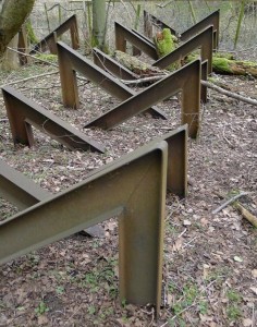
- Narborough Hairpins

-
- The Dover House Tree

EXPLOSIVES STORE
With the Home Guard having so much heavy weaponry and plans for mining sections of the village they needed somewhere to store their explosives. In the field between Dover House Farm and the river there stood a square blockhouse. It was approximately 12ft by 12ft with 13-inch-thick brick walls and a 9-inch-thick concrete slab roof with headroom of about 7ft 6ins.
The store had a remarkably flimsy wooden door; we know this because the door is still in use on a room in the barn. There was an earth bank between the store and the farm during the war and the door faced the bank. It is assumed that the door facing the bank formed a weak point for accidental explosions and as there was no habitation on the river side it was safe enough for local people. The store was demolished in 1959.
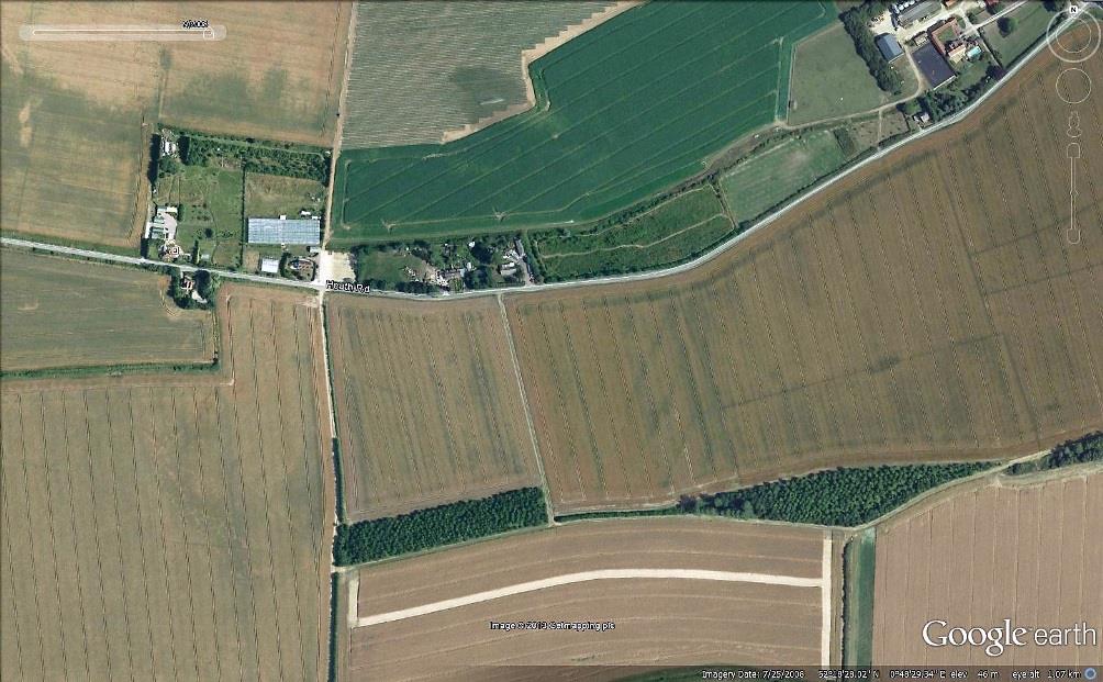
SEARCHLIGHT SITE
Not directly part of Ixworth’s defences was the searchlight site. This sat on elevated ground on the south side of Heath Road just to the west of the watermill. There was a purpose-built concrete track running up the slope which residents knew as The Searchlight Road. The site consisted of one searchlight with a generator hut and a pillbox 200 metres to the west.
-

- The searchlight site in 1945
-
- The searchlight site as it is today
DECOY AIRFIELD
Another defensive feature in the area was the decoy airfield which was in fields between the Stanton Road and the Walsham Road. This was a ‘Q’ type site which used lights to simulate an airfield (including a flare path) by night only. During the day the field was farmed. The decoy probably worked for Honington, Great Ashfield and Bury St Edmunds (Rougham). It is thought to have been bombed once during the war.
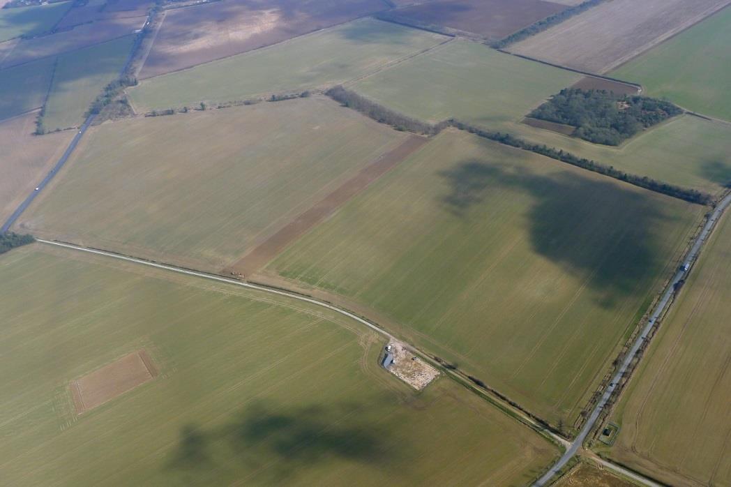
The Decoy Airfield Site
The History Group would like to thank the Suffolk Record Office for access to Major Kilner’s papers and the Suffolk Regiment Collection for agreeing to publication. His Home Guard scrapbook is held at the Bury RO (ref GB554/Y/1/636(f)). Email bury.ro@suffolk.gov.uk for queries. We would also like to thank David Reeve for his guided tour of Ixworth defences.
The pillbox film can be found at www.eafa.org.uk search for USAAF Honington.
All the images shown in this article are either authentic copies, reproductions of photos from archives or shared from other open-copyright resources online. They are reproduced here in good faith and we ask that anyone looking to reuse these images contact us for permission before using them. In many cases we may have higher definition images for you to use that we do not show online.

Ixworth’s World War Two Defences | The History Group
I have taken the great liberty of using one of your images in a Home Guard history webpage I have recently produced, dealing with a Warwickshire village platoon. I apologise for doing this without prior approval and if you object to the action do please let me know and I will remove it forthwith. The page in question is here: http://www.staffshomeguard.co.uk/DotherReminiscences127Boyles.htm
I only found your excellent page very recently and I congratulate you on it. It is a remarkable, detailed record of Home Guard activity in your village. I have given your page a mention, both in the Warwickshire page where I have used the image and also in my Suffolk summary page, obviously with an appropriate link back to you; and I hope that this will provide a few more visitors.
hello,could anyone tell me where the spigot at Moira village was originally positioned in ww11.regards James.
I read this article with interest, having once been a resident of Ixworth in my childhood. We lived at Beech Cottage in the High Street from 1952 to 1968. You did not mention one pillbox. It was sited in Crown Lane about a quarter of a mile beyond the cemetery on the same side and just off the road. I think it had been demolished by the time we left as a family.